Designated Wild and Scenic River Segments
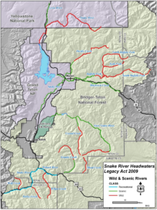
On March 30, 2009, passage of the Craig Thomas Snake Headwaters Legacy Act added all or segments of 13 rivers and streams in the Snake River Headwaters to the National Wild and Scenic Rivers System.
The Snake River Headwaters is unique in that it encompasses a connected watershed, rather than just one river or isolated rivers across a region totaling 414 miles and including:
Bailey Creek. The 6.9-mile segment of Bailey Creek from the divide with the Little Greys River north to its confluence with the Snake River: wild river.
Blackrock Creek. The 21.7-mile segment from source to the confluence with Buffalo Fork River: scenic river.
Buffalo Fork of the Snake River (2 segments). The 70.3-mile segment consisting of the North Fork, the Soda Fork, and the South Fork, upstream from Turpin Meadows: wild river. The 14.1-mile segment from Turpin Meadows to the upstream boundary of Grand Teton National Park: scenic river.
Crystal Creek (2 segments). The 14.2-mile segment from the source to the Gros Ventre Wilderness boundary: wild river. The 5-mile segment from the Gros Ventre Wilderness boundary to the confluence with the Gros Ventre River: scenic river.
Granite Creek (2 segments). The 12.5-mile segment from its source to the Wilderness boundary: wild river. The 9.7-mile segment from Wilderness Boundary to the point one mile upstream of its confluence with the Hoback: scenic river.
Gros Ventre River (2 segments). The 16.5-mile segment from its source to Darwin Ranch: wild river. The 40.1-mile segment from Darwin Ranch to the upstream boundary of Grand Teton National Park, excluding Lower Slide Lake: scenic river.
Hoback River. The segment from its confluence with the Snake River to 10.7 miles upstream: recreational river.
Pacific Creek (2 segments). The 22.5-mile segment from its source to the Teton Wilderness boundary: wild river. The 6.8-mile segment from the Wilderness boundary to the National Park Service boundary: scenic river.
Shoal Creek. The 8.5-mile segment from its source to the point 8.5 miles downstream of the source: wild river.
Snake River (3 segments). The 6.9-mile segment from its source to the Yellowstone National Park (YNP) boundary and a 2.7 mile segment below the YNP boundary along the east bank only: wild river. The 23.1-mile segment from the mouth of the Hoback River to the point one mile upstream from the Highway 89 Bridge at Alpine Junction: recreational river.
Willow Creek. The 16.2-mile segment from the point 16.2 miles upstream from its confluence with the Hoback River to its confluence with the Hoback River: wild river.
Wolf Creek. The 7-mile segment from its source to its confluence with the Snake River: wild river
To learn more about this designation, we encourage you to reach out to the Snake River Fund, or consider giving in support of protecting the Snake River Headwaters.


